Importance and Utilization of Boundary Surveys

Owning property requires understanding the location of the borders. If there are no defined borders, there will be disputes over all types of property, including private property, commercial property, and drilling and mining land. If there are conflicting views on the boundary lines, landowners may need to commission a boundary survey.
You should be aware that there can be a boundary dispute involving the property on which you want to erect your own house. Also, it could be lawful. As a result, if you don't get a survey, it could be tough to build your home. As a result, it is necessary to conduct a boundary survey.
What do you mean by boundary survey?
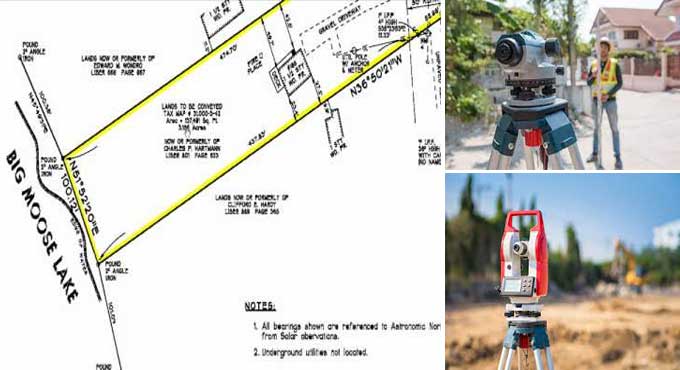
Delineating the boundaries of a property is a formal process known as a boundary survey. A land parcel's corners are determined primarily by this method. Land surveyors are often hired before people buy, divide, improve, or build on the land. An engineer will prepare a boundary survey drawing after the survey is complete.
In order to ensure accurate measurements, the survey should be conducted by a professional. There are several elements that may be included in this type of drawing:
1. Dimensions of the lot - In order to determine the dimensions of a lot, the deed, subdivision plats, and survey drawings are used. In these plans, the exact lines of the property are depicted.
2. You can commission a boundary survey that considers all previous owners' enhancements to the property. Improvements include structures like homes, barns, garages, swimming pools, and other long-term adjustments to the land.
3. Fences are frequently used to identify where your property is. However, they are rarely erected exactly on the property borders. Fences may be seen in the image, but they should not be taken as the boundaries of the property.
4. Land surveyors can add easements to drawings if they have copies of the title commitment.
What is the reason for performing a boundary survey?
In order to provide the buyer with additional proof of limits, which may be quite beneficial in the long run, this is done. Additionally, the Edmond boundary surveyor may consult with former owners and adjoining parties. The fieldwork that follows the research comprises creating a network of known crossing points as a control. In order to find and locate existing structures and other boundary evidence, the points are employed.
Even though a survey's field component is the most obvious, it normally only costs one-third as much as the entire project. The surveyor will compare the study's findings to those from the fieldwork and then reconcile all the data to ascertain any limits. The surveyor will next provide a plan, a legal description, and a report.
Upon completion, the survey will provide a property plan, detailed descriptions of buildings, and an explanation of the boundary decision. An agreement between a professional land surveyor and the buyer will determine how the borders are marked. There are many kinds of markers, from wooden stakes to pipes to concrete monuments.
What can be the cost of a Survey?
Boundary surveys cost differently depending on the project. The value of a property is determined by several factors, including the surveying firm's fees. Costs of border surveys can be influenced by a variety of factors, including:
1. Surveying a parcel of property requires an understanding of its accessibility and terrain.
2. A description of the parcel's dimensions.
3. The extent to which major land features, such as leaf cover or ground markings, change from season to season.
4. Surveyed plot's contours and dimensions.
5. The purpose of the survey.
What is the process for a boundary survey?
A boundary survey requires meticulous execution. Professionals take seriously their need to establish boundaries since it is a critical legal duty. The general steps in a border survey are as follows:
1. It is necessary to identify and verify each corner of the property, or, if the location is unknown, re-establish and reset it.
2. A marker will be placed at each corner by the surveyor. In order to provide easy visibility, the markers are usually made of rebar or iron pipe and stand around two feet tall.
3. In order to ensure clear visibility, the surveyor sprays pink paint on the corners after the markers have been placed.
4. Wooden poles or flags with labels may also be placed around property corners by surveyors.
5. At the request of the individual who commissioned the survey, permanent structures such as homes, buildings, sheds, pools, fences, and other improvements may be depicted on the boundary drawing.
6. The surveyor will note any potential encroachments.
What are some of the components of a Boundary Survey?
Deed Sketch
After the research is finished, the surveyor must get ready for the deed drawing. The surveyor must prepare a spreadsheet listing all record calls along each boundary line. The importance of research in boundary surveys can be attributed to the fact that many boundary lines have a variety of unique lengths or calls across time.
It is ideal if the research can be included with the original deed because this is typically the best way to show what the land's original grantor intended for it to be used for.
To learn more, watch the following video tutorial.
Video Source: ludlowengineering
Data Analysis
Once the surveyor has completed the field research, the data must be entered and analysed. It is examined, approved, and the accuracy of the math is verified. During the data input and analysis stage of the survey process, the surveyor determines acreage, encroachments, corner positions, easements, rights of way, and various other aspects.
The Final Planning
Once the data input and analysis are finished, the surveyor may start creating the final plan, which comprises the results of all final findings and suggestions. Typically, it is completed to a standard that enables other land surveyors to confirm the results.
The Re-evaluation
A return trip to the property's location is the last element. The surveyor must precisely identify the property corners and lines for the benefit of the property owners. The marks may be seen by some as proof that the area has been properly surveyed.