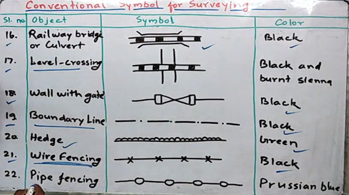
Some common types of symbols in surveying
In surveying, the objects or an area is demonstrated with symbols not by names. The civil engineer and land surveyor should have adequate knowledge on how to read the drawings, maps and plans.
In this exclusive civil engineering article, you will be familiar with various types of symbols applied land surveying.
These marks are arranged to mark key survey points on the Earth's surface.
Given below, some vital common signs and symbols found in the field of Surveying:
Surveyor flags and tape: Sometime the flags or streamers are just affixed to trees, fence posts, or provided on a stake so that they can be seen over the weeds. There should not be any markings on the stake, or only simple generic markings.
It signifies that this is the proper road and turn here. It could also signal a projected or estimated location for some future work.
Stakes with simple markings: Flags having some type of identification (it may belong to names or numbers). It is suitable for a projected well pad access road location. No dimensions are provided on these.
Stakes having simple flags and basic identification: All the stakes demonstrated here, point to an access route applicable for equipment and trucks to attain a projected pipeline right of way. The ?H310" stands for the EQT name for the 30? OVC pipeline.
Control points: These three stakes are used to recognize a control point that remains outside the limits of disturbance (LoD). These markings encircle a pin to be applied for reference.
Limit of disturbance: The ?L O D? here signifies the limits of disturbance. Outside this point, no trees cut or dirt moved should exist. The stakes signifies that this is the outside limit of where the contractor will be unsettling the original contour of the surface soil.
Pipelines: Stakes with flags and ?center line? markings are suitable for pipelines. Here, the symbol is demonstrated for center line: a capital letter ?C? levied on the letter ?L?.
Precise location markings: Stakes like this will normally contain a steel pin connected with it. This stake provides the latitude, longitude, and elevation of the site.
Permanent property lines: The markings can also be done with this one inch steel rod having an alum cap and it indicates permanent property lines and corners of property.
To get information on other types of symbols, go through this useful civil engineering video tutorial.
Video Source: Civil Engineer Deepak Kumar